HJ Education logoThe Hydro-JULES Internship 2024 programme

The Hydro-JULES intern 2024 programme is now CLOSED. Details of this years projects and application requirements are still shown below.

What is the Hydro-JULES Internship Programme?

The Hydro-JULES intern programme offers students from hydrology and environmental science backgrounds the opportunity to gain hands-on experience working at UKCEH alongside a diverse and collaborative team of Hydro-JULES scientists. 

Applicants were invited to apply to the six proposed Hydro-JULES research projects.  Successful applicants will have access to hands on learning opportunities in the scientific research sector and a meaningful work experience that will support their academic, professional and personal development. 

  • Internship dates are from Mon, 8th of July to Fri,16th of August 2024.
  • The role is based at our Wallingford site.  Hybrid working will not be considered
  • Interns will be paid at the B8 annual salary rate c. £23,914 (you will receive c. £2760. before deductions for a 6-week programme). 
  • Interviews will take place between 15th - 30 April 2024 unless stated.
  • Accommodation is NOT provided by UKCEH. Successful applicants are responsible for finding and for covering accommodation and living costs for the duration of the internship.

To be eligible?

Interns must be excellent communicators, numerate and e passionate about hydrology and climate. Depending on the project, skill sets may differ, however all applicants must:

  • Be able to work full time (37 hours per week) for the duration of the programme
  • Be in undergraduate or postgraduate (including PhD) education at university and returning to university following the placement
  • Have the right to live and work in the UK for the duration of the placement
  • Studying a relevant degree
  • Comfortable working independently with strong communication and interpersonal skills
  • Act a strong team player, comfortable both giving and receiving feedback openly

If you had applied, please ensure that the correct documentation has been submitted. 

  1. A letter of support from your supervisor, tutor, director of studies or equivalent confirming that they are content for you to undertake the proposed summer internship
  2. A covering letter explaining briefly your motivation for applying to the programme; and state which project(s) you are interested in and why
  3. A short CV indicating your educational and professional experience, and publications (if any)

 
Successful  applicants must also have agreed to the following:

  • Provide a one-page report to the Project Manager describing the visit and its accomplishments and a short testimonial within 30 days of completion of the visit
  • Appear in publicity and promotion materials for UKCEH
  • Agree to produce and present a poster, or give a presentation at Hydro-Jules event in autumn 2024
  • Acknowledge the support of Hydro-JULES funds in any publications or presentations arising from the visit

APPLICATIONS ARE NOW CLOSED.
 

Project 1 - Understanding the influence of the North Atlantic on European river flows

Supervisors: Amulya Chevuturi (UKCEH), Wilson Chan (UKCEH), and Eugene Magee(UKCEH).

The CANARI project aims to understand the influence of the North Atlantic’s large-scale atmospheric and oceanic circulation on UK weather and climate. Recent research within this project has revealed that specific North Atlantic sea-surface temperature (SST) patterns impact the UK weather, with effects observable at extended lead times. This influence can result in dry conditions and, in extreme cases, droughts in the UK, evidenced by reduced rainfall and river flow. Original study demonstrates that these SST patterns strongly correlate with elevated temperatures and reduced rainfall in Europe, with a lag of a few months. However, it is crucial to quantify this influence on European river flow patterns. This objective is important in understanding the changes in European river flows and proactively predicting such alterations to implement effective mitigation measures amid potential drought scenarios. Reference Hydrometric Networks' (RHNs) can be used for this objective by providing data from locations with minimal human impact, through the ROBIN project.  

Within this framework, the Hydro-JULES studentship program presents a project aimed at comprehending the impact of distinct North Atlantic SST patterns on European riverflows, utilizing pan-European river flow data from the ROBIN RHNs. This project will have collaborations and expertise from scientists from NOC, Southampton and NCAS, Reading. The output from this project will inform future applications of drought forecasting systems across Europe. 

The aims of this project are to: 

  • Calculate correlations between North Atlantic SST pattern indices and European river flows at varying time lags 
  • Create visualisation maps representing the relationship between the North Atlantic SST indices and European river flows  
  • Understand the teleconnections pathways linking North Atlantic Oceanic changes to European river flow variability  

The successful candidate for this project should possess: 

  • Strong numeracy/statistical skills and effective oral and written communication abilities. Proficiency in the Python/R programming language is essential 

In addition: 

  • Candidates should either hold or be actively pursuing an undergraduate degree in earth/environmental sciences or a related scientific discipline.  
  • Some experience using Linux operating system and high-performance computing (HPC) would be beneficial, but not mandatory, as training will be provided as needed.  

During this project, the student will gain an understanding of hydro-meteorology, advanced computing methods, python programming and a flavour of academic research. 

Project 2 - Characterising sub-seasonal to seasonal variability in extreme thunderstorms over India

Supervisors: Emma Barton (UKCEH), Joshua Talib (UKCEH), Cornelia Klein (UKCEH) 

Please note that interviews for Project 2, will take place between the 29th -  30 April.

Across India, large thunderstorm clusters – so-called Mesoscale Convective Systems (MCSs) - are a major component of the water cycle during the Indian Summer Monsoon (ISM), when they contribute between 50 to 70% of the total rainfall. Their sub-seasonal to seasonal (S2S; 1 to 6 week) variability can thus have a profound impact on agriculture, socio-economic status and water security across the nation, impacting the lives of over a billion people. Extreme thunderstorms in particular are associated with life threatening hazards such as flash-flooding and lightning. Accurate forecasts of increased MCS activity are hence critical for planning and hazard mitigation, yet due to the complexity of the earth system, S2S forecast skill remains low. In addition, identifying S2S drivers of extreme MCSs will help us to better benchmark climate models and their ability to capture important drivers of future rainfall extremes, for which estimates are needed to inform longer-term hydraulic infrastructure scaling. 

This project will utilise a new global storm track dataset and state-of-the-art satellite and reanalysis products to analyse S2S variability of MCSs, and investigate the key environmental drivers to storm variability. In particular, the project will investigate links between large-scale atmospheric sub-seasonal variability and the likelihood of extreme thunderstorms as defined by their precipitation and flash rates. Through this project, we will identify opportunities for improved forecasts of these extreme hydro-meteorological events across India. 

The ISM is characterised by sub-seasonal wet and dry periods. Sub-seasonal rainfall variability throughout the ISM is partly modulated by the Madden–Julian Oscillation (MJO), an atmospheric wave which modulates tropical weather on S2S timescales. The MJO controls large-scale atmospheric conditions including wind shear, humidity, and atmospheric instability, which, alongside land surface characteristics, modulate the likelihood of convective initiation and subsequent convective storm development. Observations of individual storms and atmospheric reanalysis will be used to identify the relative roles of these environmental conditions in MJO-modulated convection. Understanding how the MJO affects storm characteristics will provide valuable information for forecast development. 

The project aligns well with international efforts to understand the links between S2S atmospheric variability and local weather characteristics. Through collaborative partnerships with U.K. universities and Indian forecasting institutions, such as the University of Leeds and Indian Meteorological Department, the scientific research will support national and international efforts. 

During this six-week internship, the student will: 

  • Identify S2S variability in storm characteristics from storm tracks and satellite products 
  • Investigate the possible relationship between sub-seasonal atmospheric variability and the likelihood of extreme storms 
  • Use satellite and reanalysis products to investigate environmental drivers of storm variability 

Skillset Required: 

  • Essential – Interest in extreme weather and atmospheric dynamics 
  • Essential – Ability with a scientific programming language (preferably Python) 
  • Essential – Very good numeracy / statistical ability 
  • Desirable – Experience with remote-sensing or reanalysis datasets  

Project 3 - Assessing the performance of new Impact-based Flood Forecasting tools (Forecasting Verification Scientist)

Project Supervisors - Steven Cole (UKCEH), Robert Moore (UKCEH), Seonaid Anderson (UKCEH), Michael Cranston (SEPA) 

Across the world, operational hydro-meteorological agencies are increasingly using Impact-based Forecasting (IbF) methods to support the warning services they deliver. Many IbF and warning services, such as the Met Office National Severe Weather Warning Service and the Flood Guidance Statements from the Scottish Flood Forecasting Service and Flood Forecasting Centre, use a Risk Matrix approach that combines the potential impact and the likelihood of these impacts occurring.  

 Whilst the evaluation of hazard (e.g. rainfall or flood) forecasts against observations is well established, evaluation of IbF outputs is an emerging discipline. This project will look at evaluating the performance of the new PREDICTOR (PREDICTing flooding impacts from cOnvective Rainfall) system used by the Scottish Environment Protection Agency and developed with UKCEH and the Met Office. PREDICTOR is a next generation tool that utilises the latest Met Office convective precipitation ensemble forecasting capabilities and an impact-based forecasting approach using the National Flood Risk Assessment flood maps and was used to support the response to Storm Babet.  

  During this six-week internship, the student will: 

  • Collate impact data from official and online sources.
  • Develop methodologies for categorising impacts.
  • Evaluate the value of the PREDICTOR forecasting chain for forecasting surface water flooding impacts.
  • Work with the PREDICTOR development team.
  • Liaise with operational users and present findings from assessment.

  List of competencies / skills required: 

  • programming language (e.g. python, R) 
  • Interest in hazard forecasting and evaluation. 
  • Willingness to engage and liaise with scientists and stakeholders. 
  • Self starter wanting to innovate. 
  • Data analysis and plotting skills

Project 4 - Quantifying water and carbon intensities of UK food and bioenergy production systems

Supervisors: Brenda D’Acunha (UKCEH) & Ross Morrison (UKCEH)

The global agricultural land area is under multiple and competing pressures. A large fraction of the terrestrial surface has been converted to cropland and is essential to meeting the nutritional, energy, and resource demands of a growing human population. At the same time, the expansion and intensification of cropland systems consumes large and increasing quantities of water and nutrients, represents a major historical cause of biodiversity loss, and is a significant source of greenhouse gases (GHG) emissions to the atmosphere. These impacts are projected to intensify under future environmental change. 

This student project aims to estimate the carbon and water intensities of food and energy production for UK (and potentially global) croplands. New observational data will be analysed to assess potential trade-offs between carbon focused land management versus water use and agricultural output. The student will collate and analyse high-frequency observational data on water (evapotranspiration) and CO2 exchanged between croplands and the atmosphere across UK-Flux, a state-of-the-art national network of flux towers operated by the UK Centre for Ecology & Hydrology. Flux tower data will be combined with crop yield and crop nutritional information (i.e., calories, proteins, vitamins, fibre) to estimate the water intensity (water use per nutrient content) and carbon intensity (CO2 emission per nutrient content) of different cropping systems across a range of soil types, management practices and climatic regimes. By the end of this project, the student will create new metrics to rank food and bioenergy production systems based on their carbon emissions and water use per crop nutritional value.  

A successful candidate will have:  

Essential skills 

  • Passion, drive, and motivation to seek solutions to environmental challenges 
  • Experience using a high-level programming language for data analysis and visualisation, ideally R and/or Python 
  • Awareness of basic statistical concepts and ability to apply these to large observational datasets  
  • Experience in collating and managing large observational datasets 
  • Good oral/written communication skills and be willing to learn!  

Interest in 

  • Climate change impacts on terrestrial carbon and water cycles  
  • Land use and land use change 
  • Land based climate mitigation 
  • Sustainable land management 

Project 5 - Exploring the use of satellite observations to improve wetland inundation modelling

Supervisors: Sonja Folwell (UKCEH), Liz Cooper (UKCEH)
Advisors: Doug Clark (UKCEH)

Extreme rainfall is driving rapid expansion of wetlands in East Africa and with it an increase in methane fluxes. The largest and most complex of these systems is the Sudd which is situated in South Sudan and supplied with water from the Nile River. Land surface models that include a representation of overbank inundation can simulate wetland systems and associated methane emissions, yet they tend to underestimate the seasonal and interannual inundation variability. One key limitation in the models is that flooded extent is limited to areas close to the main river channel whereas the true extents of the largest wetlands extend beyond the main river through bifurcating river channels. Although current models are capable of simulating bifurcations, implementation and parameterisation of bifurcations is not straightforward as the model parameters to be calibrated are not directly observable. At the same time, we now have a wealth of information from earth observation datasets such as satellite borne observations of inundation extent and river altimetry that could be used to constrain our models. Traditional hydrological model calibration seeks to optimise model parameters using point timeseries information e.g., river discharge, however the aim here is to explore novel operators comparing gridded timeseries of inundation to investigate model behaviour and identify optimal parameter sets.  

This project will work towards using data assimilation to optimise the model parameters controlling bifurcations in wetland systems using observed inundation extents. We will provide existing simulations of an inundation model (CaMa-Flood) in the Upper Nile, that can be used as a test case to explore new operators and derive new parameter sets.  

The objectives of the project are to:  

  1. Review current state of the art methods for comparing satellite observations to modelled inundation. Which operators are most useful for capturing the wetland dynamics of interest?  
  2. Apply selected operator(s) to existing model output and explore model sensitivity to these. What does this tell us about model behaviour?  
  3. Generate parameter ensembles for a predefined set of bifurcation nodes and run CaMa-Flood to explore parameter uncertainty within the ensemble.  
  4. If time allows, use a DA technique to select the best parameter set and evaluate the new model.  

Lots of help will be provided to generate any additional model simulations but a successful candidate should have:  

  • experience using Python in a Linux environment  
  • some experience manipulating and visualising gridded data  
  • an awareness of basic statistical concepts relating to distributions  
  • good oral/written communication skills and be willing to learn!  

The candidate will gain an understanding of different earth observation datasets, advanced model optimisation methods and python programming. 


Apply here

Project 6 - Reservoir Storage and Release in the UK for Water Resources.

Supervisors: Helen Baron (UKCEH), Virginie Keller (UKCEH),Anna Murgatroyd (University of Oxford)
Advisors: Nathan Rickards (UKCEH)

Water resource modelling is an area of increasing importance as a combination of climate change and population growth places increased pressure on limited freshwater resources. Surface water reservoirs are a key source of water for human use in the UK and can significantly impact flow rates downstream (for example, the flow regime of the river Tyne is heavily influenced by the Kielder reservoir). It is therefore vital that reservoirs are represented in water resource models, so that an important water source is included when assessing supply-demand balance, and to improve the accuracy of river flow simulations.

In recent work, a representation of reservoirs was added to the JULES land surface model, along with other water resource management functionality. This representation uses generic reservoir routing equations (akin to those used in the H08 model) and is applicable at a coarse scale for global or regional modelling;however, these equations are not suitable for finer resolution modelling. In this project, we hope to determine a generic reservoir routing scheme that can model reservoir storage and release within a gridded water resource model at a 1km resolution. The objectives of this project are:

  • Review existing reservoir routing schemes applicable to fine-scale spatial modelling.
  • Where possible, test these routines using observed/modelled inflow, outflow, and storage data for UK reservoirs.
  • Make a recommendation on the most suitable reservoir routing scheme to be incorporated into the JULES model and/or UniFHy framework.

Depending on time, there is scope for the student to extend this work according to their interest (e.g. expanding geographical extent, exploring machine learning options, etc.).

A successful candidate will have:

  • Experience in a scientific programming language such as Python, R, Fortran.
  • Some experience in data handling and visualisation.
  • Good numerical and oral/written communication skills.
  • The candidate will gain an understanding of water resource modelling, timeseries performance metrics, and key research skills such as reviewing literature, using data, and communicating science. 

Hydro-JULES Internship Presentations - August 2023

Our two Hydro-JULES interns completed their placements with us on 18 August by presenting their work to members of the Hydro-JULES project team.

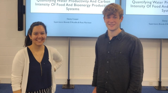
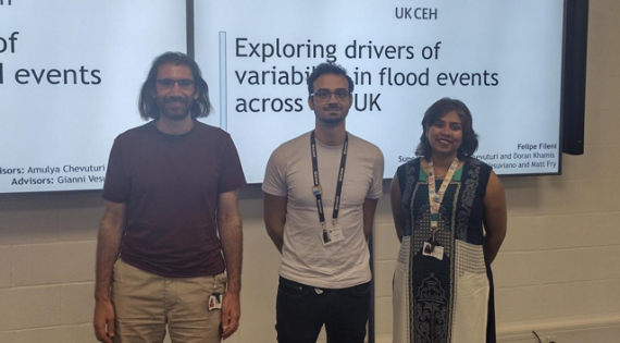
Danny Cooper mentored by Brenda D’Acunha and Ross Morrison presented his work on ‘quantifying water productivity and carbon intensity of food and bioenergy production systems' and  Felipe Feleni, mentored by Amulya Chevuturi, Doran Khamis, Gianni Vesuviano, and Matt Fry, presented his work ‘Exploring the drivers of variability in flood events across the UK’ first.'.

Image
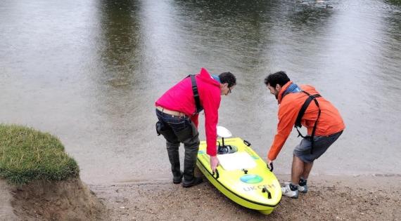
Arc Boat

Waterborne: Nick (left) and Doran launch the boat into the river Thames at Wallingford

Image
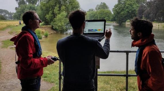
Watching the river flow: (left to right) Nick, Felipe and Doran monitor data transmitted from the ARC boat.

Watching the river flow: Nick, Felipe and Doran monitor data transmitted from the ARC boat.

Image
HJ Intern Danny Cooper

Quantifying water productivity and carbon intensity of food and bioenergy production systems

Image
HJ Intern - Felipe

I really found it useful seeing the working of the workplace with project hours etc and very much enjoyed seeing how data science and statistics is applied to different fields.
- Daniel Cooper, UEA

The project was interesting and provided an opportunity to chat with people that I knew from my PhD, as well an opportunity to meet another research environment.  Doran and Amula have been great supervisors on all matters, from technical knowledge to help with my integration with the workgroup and workplace. My advisors Gianni and Matt, have also been involved in the project  and have supported me with technical knowledge when needed.
 - Felipe Fileni, U. Newcastle

Congratulations to both Felipe and Danny for all the work they managed to achieve in their short time at UKCEH and for their excellent presentations.

For enquiries, please contact us at hydrojules@ceh.ac.uk.